Tuesday, June 9, 2015

June 7, 2015

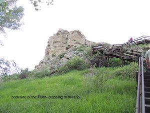
After a relaxing morning, we back tracked a little, heading east on I-90 to a National Monument Site called Pompeys Pillar. The pillar was named by William Clark of the Lewis and Clark Expedition. Clark named the pillar after the son of Sacagawea, who Clark had nicknamed Pomp, which means "Little Chief" in Shoshoni. When Clark's journals were edited in 1814 the name was changed to Pompeys Pillar, as it is know today.

William Clark scratched his name into the sandstone of the rock and dated it July 25th, 1806.

Phil took a tour of the pillar and climbed the 200+ stairs to the top while I stayed in the air conditioned visitors center. He got some really good pictures of the Yellowstone River (which is also very full and running very fast).


Sunday, June 7, 2015

June 5, 2015

Slept in for a little bit today, not in a big hurry as we only have 150 miles to do today to get to Billings, MT. However, we took one look at the black clouds building off to the west and decided to hit the road as soon as possible. We didn't want to chance a flood!

It was a beautiful drive, everything is so green from all the rains, but no evidence of any flooding in Montana. There was snow on the mountain range to the west of I-90 though, with low lying clouds just brushing to tops of the mountains.

Not far out of Billings the stupid truck did it's annoying engine light routine. Phil called the mechanic we use in Little Rock, he is doing some research. Phil has a fuel filter with him, so he is going to get that changed on the off chance that we have picked up some dirty fuel.

Tonight we went out to dinner with friends Eric and Connie, had a wonderful time catching up with them.


June 4, 2015

After a pretty nice day yesterday, shortly after we got into the truck to leave the Devils Tower KOA, it once again started to rain. Not really hard, just very steady. After about 20 minutes it started tapering off, then eventually quit.

About 15 miles before I-90 connects with I-25 at Buffalo, WY, the Powder River intersects with I-90, flowing under the interstate. Sometime during the wee morning hours of the 4th a powerful thunderstorm unleashed itself on north central Wyoming. I haven't seen the number of inches that fell, but it must have been a bucket full! When we crossed over the Powder River we could tell that the river had flooded over it's banks, carrying large pieces of deadwood across the northbound lanes, the wide grassy medium and then across the south bound lanes. It had been recent as there was mud on the interstate and crews were working at cleaning it up. 

When I bragged about the truck running so well and pulling the hills without a glitch, I may have jinxed us. About 10 miles out of Sheridan the damn engine light went off again!! &^*@($^@))$&^#$%^%#%&**&%### (Not suitable for publication!!) Knowing the drill, I wrote down the mileage, date, time and code number. So very frustrated!! This is the first time this has happened during this trip and that lead us to believe that we had it fixed.

When we got to our campground for the night (Peter D's) in Sheridan, WY, we mentioned the flooding to the owner. She told us that the storm had been so bad that the river had flooded and that the interstate had been closed until 9:00 that morning! We went through that area around 11:00 am. The campground had also been flooded, upon a closer look we could see that the gravel from the sites had been moved downhill, and she told us that the office (also at the bottom of the hill) had 2" of water in it. She had obviously been working hard because we didn't see any evidence of that.

We hadn't planned on leaving the campground, so we didn't even unhitch, the site was long enough to make that possible, with room to spare. Other than doing a few loads of wash, we just relaxed for the rest of the day. 

Wednesday, June 3, 2015

June 3, 2015

Got a good start this morning and made good time. We only had 149 miles to go and even with a few stops we were at Devils Tower in NE Wyoming by noon.

We have never been to this part of the state before, so we were looking forward to driving through here. Very much like western Nebraska, eastern Wyoming is rolling hills and is mostly pasture land. Lots of cattle and also saw lots of Antelope. Wyoming is more rocky and has sink holes exposing red clay.

We had great weather today, sunny to partly cloudy with temps that hovered around 70 - 75 with a nice breeze. However, we now have rain headed our way...again...and radar shows that there is a couple of small thunder storms embedded in the rain. The area we drove through today doesn't seem to have had as much rain effects as Nebraska had. The streams and rivers seem to be running at more normal levels...as seen through the eyes of a tourist who has never been here before. So...I wouldn't take that to the bank if I were you.

Devils Tower is fascinating to me. We have seen many rock formations in our travels all over the U.S., but none like this. Rock is generally rounded, the Tower is long ribbon like rock, almost reminds me of dreads. You can see where some of these ribbons of rock have fallen, and behind the fallen is another ribbon, so it appears that the Tower is the same all the way through! 


As we got closer to the Tower, the landscape changed pretty quickly from rolling plains to mountains with 7% grades. Good news, the truck pulled the grades like a dream, no alarms, no weird codes, just a smooth turbo clicking through the gears like it was designed to do!!! We are very pleased!!

At the base of the Tower in a large flat grassy area is a huge Prairie Dog settlement. We have seen these before, but the timing is great as the babies are out! Running, rolling and imitating Mom and Dad. Throwing their little heads back and screeching as loud as they can. I can't hear them, but that's what Phil says they are doing. Anyway you look at it they are just so cute and we sat and watched them play for awhile.


Tuesday, June 2, 2015

June 2, 2015

We left Gering, NE this morning at 9:00 am (we have been practicing getting up earlier). Continued to follow Highway 26 West to the junction of Highway 29 North. 

This part of Nebraska is hill country, with the occasional outcropping of rock, acre upon acre of pasture land, isolated farms and no store within 50 miles! To top that off...no cell service, with the exception of one cell tower in the middle that had about a 5 mile radius, then boom...gone again!!

Shortly after that marvelous cell tower we came upon the Agate Fossil Beds National Monument, our stop over point. In a nutshell, and to quote the brochure, "About 19-20 million years ago drought struck the western Nebraska plains. Deprived of food, hundreds of animals died around a few shallow water holes. Over time their skeletons were buried in the silt, fine sand, and volcanic ash carried by the wind and reworked by streams. An ancient waterhole with hundreds of fossilized skeletons is preserved today in the Niobrara River Valley at Agate Fossil Beds National Monument."  The fossil beds were discovered by the farmer who owned the land at the time, and he invited paleontologist from universities across the country to view his findings.


Tonight we are camped at BJ's Campground in Lusk, WY. We have once again dodged a very noisy thunderstorm! It looked like it was going to hit us straight on, but then veered south, giving us a little rain. 

$10,000 question for tonight...How do you know you have been driving through Mid West Farmland???? When there are hundreds of thousands of bugs plastered to the front of the rig!! 
June 1, 2015

Finally...we are in June, only 10 more days until we reach Great Falls!!!

We left North Platte this morning at 9:00 am and about 30 miles down the road we crossed into Mountain Time and gained an hour, so it was suddenly 8:30 am and we were making great time!!

Heading west on I-80, we were following the North Platte River, which is also over it's banks in many places. At one of the lower bridges there were some highway workers keeping an eye on the level of the water. There was also lots of dead wood around the standing trees and probably around the supports of the bridge as well.

At Ogallala we left I-80 and continued traveling NW on Highway 26. At Chimney Rock National Monument we stopped at the visitor's center, watched a short film, took some pictures, then ate lunch.
Chimney Rock is one of the landmarks that the pioneers used to chart their course. The route that we were driving today was also the Morman Trail, the Oregon Trail and the California Trail, so there have been a lot of people that passed this way in covered wagons. Our ancestor's were brave people!!


Tonight we are camped at the Robidoux RV Park in Gering, NE, practically at the foot of Scott's Bluff National Monument. Out our front window we have a view of the Bluff. After setting up and making a quick trip to the grocery store, we watched a storm come over the bluff. Once again we dodged the bullet, the storm split just before it got to us, with half of it going north of us and the half going south, so all we got was a little rain.


Monday, June 1, 2015

May 31, 2015

We arrived in North Platte, Nebraska on Friday, May 29th. Had pretty good weather until right after we got here, then the bottom fell out. We are at the Holiday RV Park, although not to far from the interstate, the park is pretty quiet. 

On the way here, we followed along the South Platte River, which is over it's banks in several places. The low lying bottom lands are flooded, as are the ditches right up along the interstate.

Yesterday we did the some of the sites here in North Platte. Our first stop was the Union Pacific's Bailey Yard. It's where east meets west on the UP line, and where 10,000 cars are handled each day on 2,850 acres of land stretching out eight miles. The visitor's center includes the Golden Spike Tower, which is 8 stories high. The 8th floor is enclosed with windows that give the viewer a 360* view, with displays and story lines giving the story behind what you are looking at from each window.


The 7th floor is an outside balcony, which faces the yards only. From the balcony you get the sites and sounds of the switching and rumbling of the trains as they move back and forth from track to track picking up the cars that are suppose to go with it when it leaves the yard.

One of the more interesting facts that I learned while visiting here is this: 'The wheels on a rail car are not connected. The rail car simply rests on the top of the axle of the wheels and the weight of the car and cargo hold it all together.' Amazing uh???

One of the displays in the Visitor's Center included information on the Orphan Trains. This is something that I knew about, only because my DAR chapter had a speaker on this subject last year. Our speaker was trying to trace her ancestor from the mid west where he arrived on the train, to New York where he was originally from. It adds another level of challenge to the researching process.

The Orphan Train was the brainchild of Charles Loring Brace, a young minister in New York City. He started the Children's Aid Society and devised a plan to give these homeless waifs a chance at finding families they could call their own. These were the "Throwaway Kids", living on the streets or in orphanages and foster homes.

Between 1854 and 1929, an estimated 200,000 children ventured forth on a journey of hope. Their destination was, for the most part, the farmlands of the mid west. Some of these children found a loving family waiting for them, some found they traded one hardship for another, where they were treated no better than farm laborers or worse yet, slaves. 
 

From the Bailey Yard we went to visit the Buffalo Bill Cody Ranch-Scouts Rest-which is a State Historical Park.

During his colorful life he made and spent more than one fortune, working from the age of 11 as an ox team driver (at 50 cents a day), at the age of 14 he was one of the youngest Pony Express riders.
To young to enlist in the Army during the early years of the Civil War, he served in the Union forces as ranger, dispatch bearer and scout in Missouri, Kansas and the Santa Fe Trail.

Of course, he is best known for the Buffalo Bill Wild West Show which brought the wild west to the eastern states and then Europe. It was during this time that he acquired the ranch and had the house built. 


He raised cattle and horses and introduced blooded stock to this area of the country, but he invested poorly and in 1911 he sold the ranch. He died in 1917 at his sisters home in Denver.


Just down the road from the Cody Ranch we found the Lincoln County Historical Museum. Here we found just about every antique you could hope to find, but it also gave us an inside look on how our ancestors lived, the tools they worked with, both outside and inside their houses.

One of the old log cabins was sponsored by the local DAR chapter, they had the cabin moved to the site it sits on, refurbished the building and collected what is on display. Hat's off to you ladies!!


 Phil loved the old telephone equipment, being an old telephone guy!!

The North Platte Canteen served every soldier that came through town on the Union Pacific during WWII.


Port Orford, OR

Port 6/27/2022 Phil and I drove up to Port Orford to have a look around and have lunch. We found the Port Orford Coast Guard Life Station ...