Wednesday, August 28, 2013

Lassen Volcanic National Park


August 13, 2013

Headed out a little earlier than usual this morning, had about an hours drive to reach our destination of Lassen Volcanic National Park. Lassen Peak formed 27,000 years ago, is one of the world’s largest plug dome volcanoes, rising to an elevation of 10,457’. A plug dome volcano generally has very thick lava, it moves slowly, giving plenty of warning to get out of its way.

From Redding, we headed east on Highway 44, bringing us into the park on the north side. The Visitor’s Center is at the south entrance, and key stops, view points and historical events are noted with numbered sign posts along the road, starting at the Visitor’s Center. If you have a choice, I would recommend that you stop at the Visitor’s Center and pick up a little book called “Lassen Volcanic National Park Auto Tours, Trips & Trails”. This book will follow the markers on the road and tell you what the significant event was at each marker.  We did the road backwards, and then picked up the book, we enjoy being different…anyway, the park is beautiful and at every turn there is a different view, a different landscape. There are 16 of these road markers along the 29 mile long road through the park; I’m not going to try to hit all of them.


A few are worth mentioning, I will try to keep comments brief (LOL). Also, I will note them by using the correct number of the road marker.

Stop #2 is called the Sulphur Works. You will notice a sharp sulfur smell, the ground is barren and there are clouds of steam rising from the earth, there are also mudpots boiling and steaming like pots of thick pudding.

When I was here with my family as a kid, I remember accessing these via a boardwalk, but now they are roped off and you can only view them from the sidewalk.

Stop #5 is Emerald Lake is a shallow glacial lake.
Because it is so shallow sunlight warms the water and the bottom of the lake enough for green algae to grow, creating its emerald green color.

Stop #7 is Lake Helen, larger than Emerald Lake, this lake has the look of a true alpine lake and the reflection of the surrounding trees is beautiful.
Lake Helen is about 110’ deep and stays frozen 7-8 months each year and it is believed to be somewhere between 25,000 and 120,000 years old.

Stop #9 is the Kings Creek Area.
This is a beautiful green meadow with the Kings Creek winding its way through the meadow.

Stop #11 is called the Devastated Area and well named it is! The 1915 eruptions transformed this place from a mature forest and colorful, flower filled meadow to a landscape of complete “devastation.” Parts of this area were filled with over 20’ of mud and volcanic debris as a result of the various eruptions.

Stop #14 is called Chaos Jumbles
and is another area of devastation, this one caused about 350 years ago by three large avalanches, bringing down enormous masses of rocks, pumice stone and other volcanic debris. In the years since the avalanche a forest of dwarf mixed conifers has grown up on top of the jumbled rock debris. Because there is limited soil with the nutrients needed for full growth, the trees look like young growth, but in fact may be more than 290 years old.

Lassen last exploded on May 22, 1915 with a powerful eruption that blasted rock and pumice high into the sky. A huge column of ash and gas rose more than 30,000’ and was visible as far away as 150 miles to the west. Smaller eruptions continued after the May 22nd event, in 1917 steam explosions blasted out of the smaller of the two craters on the summit. Although Lassen has been quiet for many years, the steam vents, mudpots and hot springs still found in the park are an indication that a still active reservoir of magma hides beneath the mountain. No one can say when, but it’s a pretty sure bet that someday the Lassen area will experience volcanic eruptions again.

We had a great day exploring the park, it was about 10 degrees cooler up there, the park road reaches a summit height of 8,512’. As we came out of the south entrance to the park, we followed Highway 36 back to I-5, then north back to Redding. Highway 36 was a landscape of jumbled volcanic rock. About the only thing this land can be used for is cattle grazing, no way could it be cultivated.


Wednesday, August 21, 2013

On the road to Redding, California


August 11, 2013

A down day for us, a day of rest!!


August 12, 2013

A travel day for us, on the way to Redding, CA. California is still on fire, smoke haze everywhere. So sad that there are so many of our precious trees on fire, it hurts my heart!

About half way to the town of Redding is a little mining town called Weed.
We have not traveled this road before, so I had never heard of Weed. There was a small shop with Weed T-Shirts, so we had to stop. Turns out that the back of the shop is a medical MJ pharmacy. We have seen a lot of these on this trip. In Canada they are much more obvious, there is a doctor on duty to check you out and write the script for you. The shop in Weed wasn’t as blatant.

We crossed the Sacramento River many times on our way to Redding; it’s full and running swiftly. Just south of Weed was Mt Shasta, at 14,162’, one of the tallest mountains in California. But between the cloud cover and smoke haze, its peaks were well hidden. 

My Grandparents spent many vacations at Lake Shasta,
just above Redding, and I also have many fond memories of going there with them. My Grandfather and I caught a nice string of bass there one time. I remember it as always being full of water, but when we went by it today we were shocked at how low it is. California has been hit hard by drought, but seeing Lake Shasta really made it hit home. It would have made my Grandfather really sad to see it.


For the next couple of days we are staying at the Redding RV Park. It is blazing hot, 95-100 predicted for the time we are here, but everyone keeps telling us it is a dry heat, like that is suppose to make us feel better about it. NOT!!

Saturday, August 17, 2013

Lava Beds Nat'l Monument and WW II Internment Camp


Sunday, August 10, 2013

Got up early this morning and drove down Highway 36 into California to visit the Lava Beds National Monument. It was about 50 miles, a nice day trip.

Before arriving at the Monument, we drove through the Tule Lake National Wildlife Refuge and stopped at the Visitor’s Center. Phil thought the GPS had gotten us lost, so he wanted to verify our directions. The Visitor’s Center was up on a hill overlooking Tule Lake and the wetlands that are home (temporary and permanent) to many types of birds and waterfowl.


We were not lost, so we continued on our way to the Monument. Long before we entered the park we were traveling through huge lava flows.
The Indians called this “The Land of Burnt-Out Fires,” and it covers over 46,000 acres on the northeast corner of Medicine Lake Volcano. There are more than 450 lava tube caves, the greatest concentration in North America. There is a road going through the park, but in order to see most of the tubes, you must hike. We are not hikers, but there is one tube that is close to the Visitor’s center, it is lit and has a concrete floor for safe walking.
The inside of the tube cave is interesting, but at one point we had to duck so low, going on hands and knees might have been easier.
Phil thinks it was about 150’ long, it ran downhill, then ended, so we had to retrace out steps.


It was a hot summer day, about 90 degrees outside of the tube, but inside it was a cool 60 degrees, felt really good!

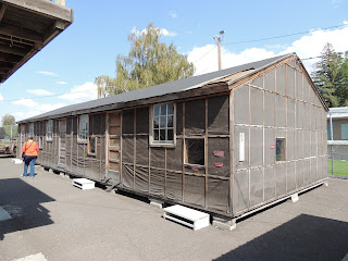
After a little more investigation around the Visitor’s Center, we headed back into the town of Tule Lake to check out the World War II Valor in the Pacific National Monument. A fancy name for Japanese Internment Camps, there were two here in this area; the Tule Lake Segregation Center, (which held 18,789 of the 120,000 men, women and children held in relocation centers throughout the U.S.) located in Newell, CA and Camp Tulelake, located just west of town. Camp Tulelake originated as a CCC camp in 1935 and was transformed into a Segregation Center in 1943. Due to the harsh conditions of the Center, strife and controversy arose. This led to the construction of a stockade, with a jail, and the implementation of martial law.  Not one of America’s finest moments!!  In 1944 it was converted into a prisoner of war camp. Remodeled by 150 Italian POW’s, it held 800 German POW’s to work in the Tulelake Basin helping local farmers harvest and tend to their fields.

The Visitor’s Center has on display a section of one of the buildings, the equivalent of a 2 bedroom apartment
and might have held 2-3 families. It’s no wonder there might have been discontent. Also on display was one of the guard towers,
as well as several farm implements from that era. It was very interesting.

Before heading home, we stopped in the only place we could find open for a quick bite to eat. It was a small dairy bar type of place, kind of like the one close to the Jr High I frequented after school when I was a kid.


Diamond Lake Drive


Wednesday, August 7, 2013

Cloudy and overcast today with a forecast of dry thunderstorms, we did get a little rain and heard some thunder a couple of times, off in the distance, but nothing severe and the sun was shining by late this afternoon.

We stayed in this morning to make some reservations for our time in California. It just hit us today that Labor Day is just around the corner and we didn’t have a firm reservation for that week end. Oops!! For the first part of the week end we had to settle for plan B, but for the second half, we got away with plan A.

This afternoon we got out for a drive around Diamond Lake. It’s a small lake, only three miles long and not very wide.
It is surrounded by the Umpqua National Forest and the tree stand is thick, especially on the west side of the lake. It was a very pretty drive, but I wouldn’t want to live there, I think I would be paranoid of forest fires all the time. On the west side there was a list of homeowners, about 100 of them! They were very well hidden in the trees, with as few trees cut as possible. We only saw traces of a dozen or so.

The cell service up here in the mountains is terrible, can’t get enough service to do the blog, can only get it to stay up a little bit at a time and it’s hit and miss. We are leaving here on Friday and will hopefully be back into the cell service world!!

Friday, August 8, 2013

Woke to dark clouds today, it was cooler as well, only 50 outside. So I snuggled up in my chair and went back to sleep. It was closer to 10 when I woke and Phil was up, taking a shower. So, got up and made some breakfast. Went back to sleep after breakfast and slept off and on all day. I think I must be having a flare up, really fatigued!!

Port Orford, OR

Port 6/27/2022 Phil and I drove up to Port Orford to have a look around and have lunch. We found the Port Orford Coast Guard Life Station ...